South Pacific country. The geographical position of the Pacific Ocean: description and features
Geographical position
The Great, or Pacific, Ocean is the greatest ocean on Earth. It accounts for about half (49%) of the area and more than half (53%) of the volume of the waters of the World Ocean, and the surface area is equal to almost a third of the entire surface of the Earth as a whole. In terms of the number (about 10 thousand) and the total area (more than 3.5 million km 2) of islands, it ranks first among the rest of the oceans of the Earth.
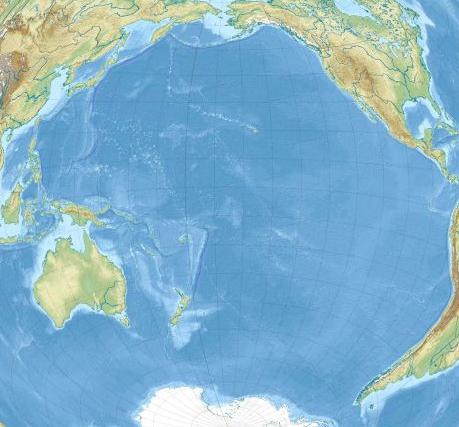
In the northwest and west, the Pacific Ocean is bounded by the shores of Eurasia and Australia, in the northeast and east by the shores of North and South America. The border with the Arctic Ocean is drawn through the Bering Strait along the Arctic Circle. The southern border of the Pacific Ocean (as well as the Atlantic and Indian) is considered the northern coast of Antarctica. When identifying the Southern (Antarctic) Ocean, its northern boundary is drawn along the waters of the World Ocean, depending on the change in the regime of surface waters from temperate latitudes to Antarctic. It runs approximately between 48 and 60°S. (Fig. 3).
Rice. 3. The boundaries of the oceans
Borders with other oceans south of Australia and South America are also conditionally drawn along the water surface: with the Indian Ocean - from Cape South East Point at about 147 ° E, with the Atlantic Ocean - from Cape Horn to the Antarctic Peninsula. In addition to a wide connection with other oceans in the south, there is communication between the Pacific and the northern part of the Indian Ocean through the interisland seas and the straits of the Sunda archipelago.
The area of the Pacific Ocean from the Bering Strait to the coast of Antarctica is 178 million km 2, the volume of water is 710 million km 3.
The northern and western (Eurasian) shores of the Pacific Ocean are dissected by seas (there are more than 20 of them), bays and straits that separate large peninsulas, islands and entire archipelagos of continental and volcanic origin. The coasts of Eastern Australia, the southern part of North America and especially South America are usually straight and difficult to access from the ocean. With a huge surface area and linear dimensions (more than 19 thousand km from west to east and about 16 thousand km from north to south), the Pacific Ocean is characterized by a weak development of the continental margin (only 10% of the bottom area) and a relatively small number of shelf seas.
Within the intertropical space, the Pacific Ocean is characterized by accumulations of volcanic and coral islands.
Ocean floor, mid-ocean ridges and transition zones
There are still different points of view on the question of the time of the formation of the Pacific Ocean in its modern form, but, obviously, by the end of the Paleozoic era, a vast reservoir already existed on the site of its basin, as well as the ancient pro-continent Pangea, located approximately symmetrically with respect to the equator . At the same time, the formation of the future Tethys Ocean began in the form of a huge bay, the development of which and the invasion of Pangea led later to its disintegration and the formation of modern continents and oceans.
The bed of the modern Pacific Ocean is formed by a system of lithospheric plates bounded from the ocean by mid-ocean ridges, which are part of the global system of mid-ocean ridges of the World Ocean. These are the East Pacific Rise and the South Pacific Ridge, which, reaching a width of up to 2,000 km in places, join together in the southern part of the ocean and continue to the west, into the Indian Ocean. The East Pacific Ridge, extending to the northeast, to the coast of North America, in the Gulf of California region, connects with the system of continental rift faults of the California Valley, the Yosemite Trench and the San Andreas Fault. The median ridges of the Pacific Ocean, in contrast to the ridges of other oceans, do not have a clearly defined axial rift zone, but are characterized by intense seismicity and volcanism with a predominance of ejecta of ultramafic rocks, i.e., they have the features of a zone of intensive renewal of the oceanic lithosphere. Throughout the entire length of the median ridges and adjacent parts of the plates are crossed by deep transverse faults, which are also characterized by the development of modern and, especially, ancient intra-plate volcanism. Located between the median ridges and bounded by deep-sea trenches and transitional zones, the vast bed of the Pacific Ocean has a complexly dissected surface, consisting of a large number of basins with a depth of 5000 to 7000 m or more, the bottom of which is composed of oceanic crust covered with deep-sea clays, limestones and silts of organic origin. . The relief of the bottom of the basins is predominantly hilly. The deepest basins (about 7000 m or more): Central, West Mariana, Philippine, South, Northeast, East Caroline.
The basins are separated from each other or crossed by arched uplifts or blocky ridges, on which volcanic structures are planted, often crowned with coral structures within the intertropical space. Their peaks protrude above the water in the form of small islands, often grouped into linearly elongated archipelagos. Some of them are still active volcanoes, spewing basaltic lava flows. But for the most part, these are already extinct volcanoes built on coral reefs. Some of these volcanic mountains are located at a depth of 200 to 2000 m. Their peaks are leveled by abrasion; the position deep under water is obviously associated with the lowering of the bottom. Formations of this type are called guyots.
Of particular interest among the archipelagos of the Central Pacific Ocean are the Hawaiian Islands. They form a chain 2500 km long, stretched north and south of the Tropic of the North, and are the tops of huge volcanogenic massifs rising from the ocean floor along a powerful deep fault. Their visible height is from 1000 to 4200 m, and the underwater one is approximately 5000 m. In terms of their origin, internal structure and appearance, the Hawaiian Islands are a typical example of oceanic intra-plate volcanism.
The Hawaiian Islands are the northern outskirts of the huge island group of the central Pacific Ocean, which bears the common name "Polynesia". The continuation of this group up to about 10°S. are the islands of Central and Southern Polynesia (Samoa, Cook, Society, Tabuai, Marquesas, etc.). These archipelagos, as a rule, are elongated from the northwest to the southeast, along the lines of transform faults. Most of them are of volcanic origin and are composed of strata of basaltic lava. Some are crowned with wide and gentle volcanic cones 1000-2000 m high. The smallest islands in most cases are coral buildings. Numerous clusters of small islands, located mainly north of the equator, in the western part of the Pacific lithospheric plate, have similar features: the Mariana, Caroline, Marshall and Palau islands, as well as the Gilbert archipelago, which partially enters the southern hemisphere. These groups of small islands are collectively known as Micronesia. All of them are of coral or volcanic origin, are mountainous and rise hundreds of meters above sea level. The coasts are surrounded by surface and underwater coral reefs, which greatly impede navigation. Many small islands are atolls. Near some of the islands there are deep ocean trenches, and to the west of the Mariana Archipelago there is a deep-water trench of the same name, which belongs to the transition zone between the ocean and the Eurasian continent.
In the part of the Pacific Ocean bed adjacent to the American continents, small isolated volcanic islands are usually scattered: Juan Fernandez, Cocos, Easter, etc. The largest and most interesting group is the Galapagos Islands, located near the equator near the coast of South America. This is an archipelago of 16 large and many small volcanic islands with peaks of extinct and active volcanoes up to 1700 m high.
The transitional zones from the ocean to the continents are distinguished by the structure of the ocean floor and the features of tectonic processes both in the geological past and at the present time. They encircle the Pacific Ocean in the west, north and east. In different parts of the ocean, the processes of formation of these zones proceed differently and lead to different results, but everywhere they are very active both in the geological past and at the present time.
From the side of the ocean floor, the transition zones are limited by arcs of deep-sea trenches, in the direction of which the lithospheric plates move and the oceanic lithosphere sinks under the continents. Within the transition zones, the structure of the ocean floor and the marginal seas is dominated by transitional types of the earth's crust, and oceanic types of volcanism are replaced by mixed volcanic-explosive volcanism of subduction zones. Here we are talking about the so-called "Pacific Ring of Fire", which encircles the Pacific Ocean and is characterized by high seismicity, numerous manifestations of paleovolcanism and volcanic landforms, as well as the existence within its limits of more than 75% of the planet's currently active volcanoes. Basically, this is a mixed effusive-explosive volcanism of medium composition.
Most clearly all the typical features of the transition zone are expressed within the northern and western margins of the Pacific Ocean, that is, off the coast of Alaska, Eurasia and Australia. This wide strip between the ocean floor and land, including the underwater margins of the continents, is unique in terms of the complexity of its structure and the ratio between land and water area, it is distinguished by significant fluctuations in depths and heights, the intensity of processes occurring both in the depths of the earth's crust and on the water surface.
The outer margin of the transition zone in the north Pacific Ocean is formed by the Aleutian deep-sea trench, which extends for 4000 km in a convex arc southward from the Gulf of Alaska to the shores of the Kamchatka Peninsula, with a maximum depth of 7855 m. This trench, towards which the movement of lithospheric plates of the northern part of the Pacific Ocean faces, from the rear it borders the underwater foot of the chain of the Aleutian Islands, most of them are volcanoes of the explosive-effusive type. About 25 of them are active.
Mankind has always been attracted by secrets hidden from its sight. From the boundless expanses of the Universe to the deepest points of the World Ocean... Modern technologies partially make it possible to learn some secrets of the Earth, Water and Space. The more the veil of secrecy opens, the more a person wants to know, because new knowledge gives rise to questions. The largest, oldest and least explored Pacific Ocean is no exception. Its influence on the processes that take place on the planet is obvious: it is it that makes it possible for a deeper and more thorough study. The average depth, the direction of currents, communication with the seas and other water bodies - everything matters for the optimal use of man's unlimited resources.
World Ocean
All biological species on Earth depend on water, it is the basis of life, so the importance of studying the hydrosphere in all its manifestations becomes a priority for humanity. In the process of forming this knowledge, much attention is paid to both fresh sources and huge volumes of salt resources. The world ocean is the main part of the hydrosphere, which occupies 94% of the earth's surface. and archipelagos share water spaces, which makes it possible to territorially designate them on the face of the planet. On the modern map of the world since 1953, the international hydrogeographic society has marked four Indian, Arctic and Pacific. Each of them has the corresponding coordinates and boundaries, which are rather arbitrary for the movement of water flows. Relatively recently, the fifth ocean was singled out - the Southern Ocean. All of them differ significantly in area, water volumes, depths and composition. More than 96% of the entire hydrosphere is salty ocean water, which moves in vertical and horizontal directions and has its own global mechanism for metabolism, creation and use of energy flows. In the life of a modern person, the World Ocean plays a significant role: it forms the climatic conditions on the continents, provides an indispensable transport structure, gives people a lot of resources, including biological ones, and at the same time remains an ecosystem, the possibilities of which have not yet been fully explored.
Pacific Ocean
49.5% of the area of the World Ocean and 53% of the volume of its water resources is occupied by its most ancient and mysterious part. The Pacific Ocean with incoming seas has the greatest extent of its water area: from north to south - 16 thousand km, from west to east - 19 thousand km. Most of it is located in the southern latitudes. The most significant are the numerical expressions of quantitative characteristics: volume - 710 million km 3, occupied area - almost 180 million km 3. The average depth of the Pacific Ocean, according to various estimates, varies from 3900 to 4200 meters. The only continent that is not washed by its waters is Africa. More than 50 states are located on its coast and islands, with all parts of the hydrosphere it has conditional boundaries and a constant exchange of flows. The number of islands located in the Pacific Ocean exceeds 10 thousand, they have different sizes and structure of formation. More than 30 seas are included in its water area (including internal ones), their area occupies 18% of the entire surface, the largest part is located on the western coast and washes Eurasia. The greatest depth of the Pacific Ocean, like the entire World Ocean, is in the Mariana Trench. Its research has been going on for more than 100 years, and the more information about the deep-sea quarry becomes available, the more it is of interest to scientists around the world. The shallowest depth of the Pacific Ocean is observed in its coastal zones. They have been studied quite well, but, given their constant use in human economic activity, the need for further scientific research is increasing.
History of development
The peoples who inhabited the Pacific coast on different continents knew a lot about its individual parts, but did not represent the full power and size of this body of water. The first European who saw a small coastal bay was the Spaniard - the conquistador Vasco de Balboa, who for this overcame the high mountain ranges of the Isthmus of Panama. He took what he saw for the sea and called it the South. That is why the discovery of the Pacific Ocean and giving it its present name is the merit of Magellan, who was very lucky with the conditions in which he crossed its southern part. This name does not at all correspond to the true nature of this aquatic giant, but it has taken root more than all the others that have been proposed as it has been studied. Many expeditions followed in the footsteps of Magellan, the Pacific Ocean attracted new researchers with a large number of questions. The Dutch, the British, the Spaniards were looking for ways to communicate with known lands and in parallel opened new ones. Everything was of interest to researchers: what is the greatest depth of the Pacific Ocean, the speed and direction of movement of water masses, salinity, flora and fauna of waters, etc. Scientists managed to collect more accurate information in the 19th-20th centuries, this is the period of formation of oceanology as a science. But the first attempt to determine the depth of the Pacific Ocean was made by Magellan using a hemp line. He failed - the bottom could not be reached. A lot of time has passed since then, and today the results of ocean depth measurements can be seen on any map. Modern scientists use improved technology and can, with a high degree of probability, indicate where the depth of the Pacific Ocean is maximum, where places with a lower level lie, and where shoals lie.

Bottom relief
More than 58% of the earth's surface is occupied by the ocean floor. It has a varied relief - these are large plains, high ridges and deep depressions. In percentage terms, the ocean floor can be divided as follows:
- Continental shallow (depth from 0 to 200 meters) - 8%.
- Continental slopes (from 200 to 2500 meters) - 12%.
- Ocean bed (from 2500 to 6000 meters) - 77%.
- Maximum depths (from 6000 to 11000 meters) - 3%.
The ratio is quite approximate, 2/3 of the ocean floor was measured, and the data of various research expeditions may vary due to constant movement. The accuracy of measuring instruments increases every year, the information obtained earlier is corrected. In any case, the greatest depth of the Pacific Ocean, its minimum value and the average value depend on the topography of the ocean floor. The smallest depths, as a rule, are observed in the territory adjacent to the continents - this is the coastal part of the oceans. It can have a length of 0 to 500 meters, the average varies within 68 meters.

The continental shelf is characterized by a slight slope, that is, it is flat, with the exception of the coasts, on which the mountain ranges are located. In this case, the relief is quite diverse, depressions and bottom cracks can reach a depth of 400-500 meters. The minimum depth of the Pacific Ocean is less than 100 meters. The large reef and its lagoons with warm clear water provide a unique opportunity to see everything that happens on the bottom. Continental slopes also vary in slope and length, depending on the location of the coastal region. Their typical structure has a smooth, gradually lowering relief or the presence of a deep canyon. They tried to explain this fact in two versions: tectonic and flooding of river valleys. The latter assumption is supported by soil samples from their bottom, which also contains silt. These canyons are quite deep, due to their average depth of the Pacific Ocean is quite impressive. The bed is a flatter part of the relief with constant depth. Cracks, crevices and depressions at the bottom of the World Ocean are a frequent phenomenon, and the maximum value of their depths, as already mentioned, is observed in the Mariana Trench. The relief of the bottom of each area is individual, it is fashionable to compare it with land landscapes.
Features of the relief of the Pacific Ocean
The depth of the abysses in the Northern Hemisphere and a significant part of the Southern Hemisphere (and this is more than 50% of the entire area of the ocean floor) varies within 5000 meters. In the northwestern part of the ocean, there are a large number of depressions and cracks that are located along the edge of the coastal zone, in the region of the continental slope. Almost all of them coincide with mountain ranges on land and have an oblong shape. This is typical for the coast of Chile, Mexico and Peru, and this group also includes the Aleutian northern basin, the Kuril and Kamchatka. In the Southern Hemisphere, a depression 300 meters long is located along the islands of Tonga, Kermadec. To find out how deep the Pacific Ocean is on average, people used various measuring instruments, the history of which is closely connected with research work in the water spaces of the planet.
Depth gauges

Lot is the most primitive means of depth measurement. It's a rope with a load on the end. This tool is not suitable for measuring sea and ocean depths, since the weight of the lowered cable will exceed the weight of the load. The results of the measurement with the help of the lot gave a distorted picture or did not bring any results at all. An interesting fact: Brook's lot was actually invented by Peter 1. His idea was that a load was attached to the cable, which popped up when it hit the bottom. This stopped the process of lowering the lot and made it possible to determine the depth. A more advanced depth gauge worked on the same principle. Its feature was the possibility of capturing part of the soil for further research. All these measuring devices have a significant drawback - the measurement time. To fix the value of a large depth, the cable must be lowered in stages over several hours, while the research vessel must stand in one place. Over the past 25 years, soundings have been carried out with the help of an echo sounder, which works on the principle of signal reflection. The operating time has been reduced to a few seconds, while on the echogram you can view the types of bottom soils and detect sunken objects. To determine what the average depth of the Pacific Ocean is, it is necessary to take a large number of measurements, which are then summed up, as a result, the delta is calculated.
History of soundings
The 19th century is "golden" for oceanography in general and the Pacific Ocean in particular. The first expeditions of Kruzenshtern and Lisyansky set as their goal not only the measurement of depths, but also the determination of temperatures, pressure, density and salinity of water. 1823-1826: taking part in the research work of O. E. Kotzebue, the physicist E. Lenz used the bathometer he created. The year 1820 was marked by the discovery of Antarctica, the expedition of navigators F. F. Bellingshausen and M. P. Lazarev studied the northern seas of the Pacific Ocean. At the end of the 20th century (1972-1976), the British vessel Challenger carried out a comprehensive oceanographic survey, which provided most of the information used to this day. Since 1873, the United States, with the help of the navy, measured the depths and fixed the topography of the Pacific Ocean floor for laying a telephone cable. The 20th century was marked by a technological breakthrough for all mankind, which largely affected the work of Pacific Ocean researchers, who asked a lot of questions. Swedish, British and Danish expeditions set off on a round-the-world trip to explore the largest body of water on our planet. How deep is the Pacific Ocean at its maximum and minimum? Where are these points located? What underwater or surface currents influence them? What caused them to form? The study of the bottom was carried out for a long time. From 1949 to 1957, the crew of the Vityaz research ship mapped many relief elements on a map of the Pacific Ocean floor and tracked its currents. The watch was continued by other vessels that constantly cruised in the water area to obtain the most accurate and timely information. In 1957, the scientists of the Vityaz vessel determined the point at which the greatest depth of the Pacific Ocean is observed - the Mariana Trench. Until today, its bowels are carefully studied not only by oceanologists, but also by biologists, for whom there was also a lot of interesting things.
Mariana Trench
The trench stretched for 1500 meters along the islands of the same name in the western part of the Pacific coast. It looks like a wedge and has varying depths throughout. The history of occurrence is connected with the tectonic activity of this part of the Pacific Ocean. In this segment, it gradually goes under the Philippine one, moving 2-3 cm per year. At this point, the depth of the Pacific Ocean is maximum, and the depth of the World Ocean too. Measurements have been taken for hundreds of years, and each time their values are corrected. The 2011 study gives the most surprising result, which may not be conclusive. The deepest point of the Mariana Trench is the "Challenger Abyss": the bottom is at a distance of 10,994 m below sea level. For its study, a bathyscaphe equipped with cameras and devices for soil sampling was used.
How deep is the Pacific Ocean?
There is no unequivocal answer to this question: the bottom topography is so complex and not fully understood that each figure mentioned can be corrected in the near future. The average depth of the Pacific Ocean is 4,000 meters, the smallest is less than 100 meters, the famous "Challenger Abyss" is characterized by impressive figures - almost 11,000 meters! There are a number of depressions along the mainland, which also amaze with their depths, for example: the Vityaz 3 depression (Tonga trench, 10,882 meters); "Argo" (9165, Northern New Hebrides Trench); Cape Johnson (Philippine Trench, 10,497), etc. The Pacific Ocean contains the largest number of the deepest points of the World Ocean. Modern oceanologists expect a lot of interesting work and amazing discoveries.
Flora and fauna
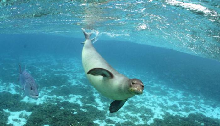
Notable for researchers is the fact that even at a maximum depth of 11,000 meters, biological activity was found: tiny microorganisms survive without light, while being subjected to the monstrous pressure of many tons of water. The vastness of the Pacific Ocean itself is an ideal habitat for many species of animals and plants. Which is confirmed by facts and concrete figures. More than 50% of the biomass of the World Ocean lives in the Pacific, the diversity of species is explained by the fact that vast expanses of water are located in all belts of the planet. Tropical and subtropical latitudes are more densely populated, but the northern borders are not empty either. A characteristic feature of the fauna of the Pacific Ocean is endemism. Here are the habitats of the most ancient animals of the planet, endangered species (sea lions, sea otters). Coral reefs are one of the wonders of nature, and the richness of flora and fauna attracts not only a lot of tourists, but also explorers. The Pacific Ocean is the largest and most powerful. The task of people is to study and understand all the processes taking place in it, which will help reduce the degree of harm caused by humans to this unique ecosystem.
The Pacific Ocean is the largest of the oceans. Its area is 178.7 million km 2. The ocean surpasses in area all the continents combined, and has a rounded configuration: it is noticeably elongated from the northwest to the southeast, therefore air and water masses reach the greatest development here in the vast northwestern and southeastern water areas. The length of the ocean from north to south is about 16 thousand km, from west to east - more than 19 thousand km. It reaches its maximum width in the equatorial-tropical latitudes, so it is the warmest of the oceans. The volume of water is 710.4 million km 3 (53% of the water volume of the World Ocean). The average depth of the ocean is 3980 m, the maximum is 11,022 m (Marian Trench).
The ocean washes with its waters the shores of almost all continents except Africa. It reaches Antarctica on a broad front, and its cooling influence extends through the waters far to the north. On the contrary, Quiet is protected from cold air masses by considerable isolation (the close location of Chukotka and Alaska with a narrow strait between them). In this regard, the northern half of the ocean is warmer than the southern. The Pacific Ocean basin is connected to all other oceans. The boundaries between them are rather arbitrary. The most reasonable border with the Arctic Ocean: it runs along the underwater rapids of the narrow (86 km) Bering Strait somewhat south of the Arctic Circle. The border with the Atlantic Ocean runs along the wide Drake Passage (along the line Cape Horn in the archipelago - Cape Sternek on the Antarctic Peninsula). The border with the Indian Ocean is conditional.
Usually it is carried out as follows: the Malay Archipelago is assigned to the Pacific Ocean, and between Australia and Antarctica the oceans delimit along the meridian of the South Cape (Tasmania Island, 147 ° E). The official boundary with the Southern Ocean ranges from 36° S. sh. off the coast of South America to 48 ° S. sh. (at 175°W). The outlines of the coastline are quite simple on the eastern margin of the ocean and very complex on the western margin, where the ocean occupies a complex of marginal and interisland seas, island arcs, and deep-water trenches. This is a vast region of the largest horizontal and vertical dissection of the earth's crust on Earth. The marginal type includes seas off the coast of Eurasia and Australia. Most of the inter-island seas are located in the area of the Malay Archipelago. They are often combined under the general name of the Australo-Asiatic. The seas are separated from the open ocean by numerous groups of islands and peninsulas. Island arcs are usually accompanied by deep-sea trenches, the number and depth of which is unparalleled in the Pacific Ocean. The coasts of North and South America are slightly indented, there are no marginal seas and such large clusters of islands. Deep-sea trenches are located directly off the coasts of the continents. Off the coast of Antarctica in the Pacific sector there are three large marginal seas: Ross, Amundsen and Bellingshausen.
The margins of the ocean, together with the adjacent parts of the continents, are included in the Pacific mobile belt ("ring of fire"), which is characterized by powerful manifestations of modern volcanism and seismic activity.
The islands of the central and southwestern parts of the ocean are united under the general name Oceania.
Its unique records are associated with the huge size of the Pacific Ocean: it is the deepest, the warmest on the surface, the highest wind waves are formed here, the most destructive tropical hurricanes and tsunamis, etc. The position of the ocean in all latitudes determines the exceptional diversity of its natural conditions and resources .
Occupying about 1/3 of the surface of our planet and almost 1/2 of the area, the Pacific Ocean is not only a unique geophysical object of the Earth, but also the largest region of multilateral economic activity and diverse interests of mankind. Since ancient times, the inhabitants of the Pacific shores and islands have mastered the biological resources of coastal waters and made short voyages. Over time, other resources began to be involved in the economy, their use gained a wide industrial scope. Today, the Pacific Ocean plays a very important role in the life of many countries and peoples, which is largely determined by its natural conditions, economic and political factors.
Features of the economic and geographical position of the Pacific Ocean
In the north, vast expanses of the Pacific Ocean through the Bering Strait are connected to the Arctic Ocean.
The border between them runs along a conditional line: Cape Unikyn (Chukotka Peninsula) - Shishmareva Bay (Seward Peninsula). In the west, the Pacific Ocean is bounded by the mainland of Asia, in the southwest by the shores of the islands of Sumatra, Java, Timor, then by the east coast of Australia and a conditional line crossing the Bass Strait and then following along the coast of Tasmania, and to the south along the ridge of underwater rises to Cape Alden on Wilkes Land in . The coasts of North and South America serve as the eastern limits of the ocean, and to the south - a conditional line from the island of Tierra del Fuego to the Antarctic Peninsula on the mainland of the same name. In the extreme South, the waters of the Pacific Ocean wash Antarctica. Within these limits, it occupies an area of 179.7 million km2, including marginal seas.
The ocean has a spherical shape, especially pronounced in the northern and eastern parts. Its greatest extent in latitude (about 10,500 miles) is noted along the parallel of 10°N, and the greatest length (about 8,500 miles) falls on the meridian of 170°W. Such great distances between the northern and southern, western and eastern shores are an essential natural feature of this ocean.
The coastline of the ocean is strongly indented in the west, in the east the coasts are mountainous and poorly dissected. In the north, west and south of the ocean there are large seas: Bering, Okhotsk, Japan, Yellow, East China, South China, Sulawesi, Yavan, Ross, Amundsen, Bellingshausen, etc.
The bottom relief of the Pacific Ocean is complex and uneven. In most of the transition zone, the shelves do not have significant development. For example, off the American coast, the width of the shelf does not exceed several tens of kilometers, but in the Bering, East China, and South China seas, it reaches 700-800 km. In general, the shelves occupy about 17% of the entire transition zone. Continental slopes are steep, often stepped, dissected by submarine canyons. The ocean bed occupies a huge space. By a system of large uplifts, ridges and individual mountains, wide and relatively low swells, it is divided into large basins: Northeast, Northwest, East Mariana, West Caroline, Central, South, etc. The most significant East Pacific uplift is included in world system of mid-ocean ridges. In addition to it, large ridges are common in the ocean: Hawaiian, Imperial Mountains, Carolina, Shatsky, etc. A characteristic feature of the topography of the ocean floor is the confinement of the greatest depths to its periphery, where deep-sea trenches are located, most of which are concentrated in the western part of the ocean - from the Gulf of Alaska to New Zealand.
The vast expanses of the Pacific Ocean cover all natural belts from the northern subpolar to the southern polar, which is the reason for the diversity of its climatic conditions. At the same time, the most significant part of the ocean space, located between 40 ° N. sh. and 42 ° S, is located within the equatorial, tropical and subtropical zones. The southern marginal part of the ocean is climatically more severe than the northern one. Due to the cooling effect of the Asian continent and the predominance of west-east transport, typhoons are characteristic of temperate and subtropical latitudes of the western part of the ocean, especially frequent in June-September. The northwestern part of the ocean is characterized by monsoons.
Exceptional dimensions, peculiar outlines, large-scale atmospheric processes largely determine the features of the hydrological conditions of the Pacific Ocean. Since a fairly significant part of its area is located in equatorial and tropical latitudes, and the connection with the Arctic Ocean is very limited, since the water on the surface is higher than in other oceans and is equal to 19’37 °. The predominance of precipitation over evaporation and a large river runoff cause a lower salinity of surface waters than in other oceans, the average value of which is 34.58% o.
The temperature and salinity on the surface vary both by water area and by season. The most noticeable seasonal changes in temperature in the western part of the ocean. Seasonal fluctuations in salinity are generally small. Vertical changes in temperature and salinity are observed mainly in the upper 200-400 m layer. At great depths they are insignificant.
The general circulation in the ocean consists of horizontal and vertical movements of water, which are traced to some extent from the surface to the bottom. Under the influence of large-scale atmospheric circulation over the ocean, surface currents form anticyclonic gyres in subtropical and tropical latitudes and cyclonic gyres in northern temperate and southern high latitudes. The ring-shaped movement of surface waters in the northern part of the ocean is formed by the North trade wind, Kuroshio, North Pacific warm currents, California, Kuril cold and Alaska warm. The system of circular currents in the southern regions of the ocean includes the warm South Trade Winds, the East Australian, the zonal South Pacific, and the cold Peruvian. The rings of currents of the northern and southern hemispheres during the year separate the Inter-trade current, passing north of the equator, in the band between 2-4 ° and 8-12 ° N. latitude. The speeds of surface currents are different in different regions of the ocean and change with the seasons. Vertical water movements of different mechanism and intensity are developed throughout the ocean. In the surface horizons, density mixing occurs, which is especially significant in areas of ice formation. In areas of convergence of surface currents, surface waters sink and underlying waters rise. The interaction of surface currents and vertical water movements is one of the most important factors in the formation of the structure of waters and water masses in the Pacific Ocean.
In addition to these main natural features, the economic development of the ocean is strongly influenced by the social and economic conditions characterized by the EGP of the Pacific Ocean. In relation to the land spaces gravitating towards the ocean, the EGP has its own distinctive features. The Pacific Ocean and its seas wash the coasts of three continents, on which there are more than 30 coastal states with a total population of about 2 billion people, i.e. about half of humanity lives here.
Countries - Russia, China, Vietnam, USA, Canada, Japan, Australia, Colombia, Ecuador, Peru, etc. - go to the Pacific Ocean. Each of the three main groups of Pacific states includes countries and their regions with a more or less high level of economic development . This affects the nature and possibilities of using the ocean.
The length of the Pacific coast of Russia is more than three times the length of the coastline of our Atlantic seas. In addition, unlike the western ones, the Far Eastern sea coasts form a continuous front, which facilitates economic maneuvering in its individual sections. However, the Pacific Ocean is far from the main economic centers and densely populated areas of the country. This remoteness is, as it were, reduced as a result of the development of industry and transport in the eastern regions, but nevertheless it significantly affects the nature of our relations with this ocean.
Almost all mainland states and many island states, with the exception of Japan, adjacent to the Pacific basin, have large reserves of diverse natural resources that are being intensively developed. Consequently, the sources of raw materials are distributed relatively evenly along the periphery of the Pacific Ocean, and the centers of its processing and consumption are located mainly in the northern part of the ocean: in the USA, Japan, Canada and, to a lesser extent, in Australia. The uniform distribution of natural resources along the coast of the ocean and the confinement of their consumption to certain centers is a characteristic feature of the EGP of the Pacific Ocean.
Continents and partially islands in vast spaces separate the Pacific Ocean from other oceans by natural boundaries. Only to the south of Australia and New Zealand are the Pacific waters connected by a wide front to the waters of the Indian Ocean, and through the Strait of Magellan and the Drake Strait - to the waters of the Atlantic. In the north, the Pacific Ocean is connected to the Arctic Ocean by the Bering Strait. In general, the Pacific Ocean, excluding its sub-Antarctic regions, is connected to other oceans in a relatively small part. Ways, its communications with the Indian Ocean pass through the Australo-Asian seas and their straits, and with the Atlantic - through the Panama Canal and the Strait of Magellan. The narrowness of the straits of the seas of Southeast Asia, the limited capacity of the Panama Canal, and the remoteness from major world centers of the vast expanses of Antarctic waters reduce the transport capabilities of the Pacific Ocean. This is an important feature of his EGP in relation to the world's sea routes.
The history of the formation and development of the basin
The pre-Mesozoic stage of the development of the World Ocean is largely based on assumptions, and many questions about its evolution remain unclear. Regarding the Pacific Ocean, there is a lot of indirect evidence indicating that the Paleo-Pacific Ocean has existed since the middle of the Precambrian. It washed the only continent of the Earth - Pangea-1. It is believed that direct evidence of the antiquity of the Pacific Ocean, despite the youth of its modern crust (160-180 million years), is the presence of ophiolite rock associations in folded systems found throughout the continental periphery of the ocean and having an age up to the Late Cambrian. The history of ocean development in the Mesozoic and Cenozoic times has been more or less authentically reconstructed.
The Mesozoic stage, apparently, played a large role in the evolution of the Pacific Ocean. The main event of the stage is the collapse of Pangea II. In the Late Jurassic (160-140 million years ago), the opening of the young Indian and Atlantic Oceans took place. The growth of their bed (spreading) was compensated by the reduction in the area of the Pacific Ocean and the gradual closure of the Tethys. The ancient oceanic crust of the Pacific Ocean sank into the mantle (subduction) in the Zavaritsky-Benioff zones, which bordered the ocean, as at the present time, with an almost continuous strip. At this stage in the development of the Pacific Ocean, its ancient mid-ocean ridges were restructured.
The formation in the Late Mesozoic of folded structures in northeast Asia and Alaska separated the Pacific Ocean from the Arctic Ocean. In the east, the development of the Andean belt swallowed up the island arcs.
Cenozoic stage
The Pacific Ocean continued to shrink due to the thrust of the continents on it. As a result of the continuous movement of America to the west and the absorption of the ocean floor, the system of its median ridges turned out to be significantly shifted to the east and southeast, and even partially submerged under the continent of North America in the Gulf of California. The marginal seas of the northwestern water area also formed, and the island arcs of this part of the ocean acquired their modern form. In the north, during the formation of the Aleutian island arc, the Bering Sea split off, the Bering Strait opened up, and the cold waters of the Arctic Ocean began to flow into the Pacific Ocean. The basins of the Ross, Bellingshausen and Amundsen seas formed off the coast of Antarctica. There was a major fragmentation of the land that connected Asia and Australia, with the formation of numerous islands and seas of the Malay Archipelago. The marginal seas and islands of the transitional zone to the east of Australia acquired a modern look. An isthmus between the Americas formed 40-30 million years ago, and the connection between the Pacific Ocean and the Atlantic Ocean in the Caribbean region was finally interrupted.
Over the past 1-2 million years, the size of the Pacific Ocean has decreased very slightly.
The main features of the bottom topography
As in other oceans, all the main planetary morphostructural zones are clearly distinguished in the Pacific: the underwater margins of the continents, transitional zones, the ocean floor, and mid-ocean ridges. But the general plan of the bottom topography, the ratio of areas and the location of these zones, despite a certain similarity with other parts of the World Ocean, are distinguished by great originality.
The underwater margins of the continents occupy about 10% of the area of the Pacific Ocean, which is much less in comparison with other oceans. The continental shelf (shelf) accounts for 5.4%.
The shelf, like the entire underwater margin of the continents, reaches its greatest development in the western (Asiatic-Australian) coastal sector, in the marginal seas - the Bering, Okhotsk, Yellow, East China, South China, seas of the Malay Archipelago, as well as to the north and east from Australia. The shelf is wide in the northern part of the Bering Sea, where there are flooded river valleys and traces of relict glacial activity. In the Sea of Okhotsk, a submerged shelf (1000-1500 m deep) is developed.
The continental slope is also wide, with signs of fault-block dissection, cut by large underwater canyons. The continental foot is a narrow plume of accumulation of the products of the removal of turbidity flows and landslide masses.
To the north of Australia is a vast continental shelf with the widespread development of coral reefs. In the western part of the Coral Sea there is a unique structure of the Earth - the Great Barrier Reef. This is a discontinuous strip of coral reefs and islands, shallow bays and straits, stretching in the meridional direction for almost 2500 km, in the northern part the width is about 2 km, in the southern part up to 150 km. The total area is more than 200 thousand km 2. At the base of the reef lies a thick layer (up to 1000-1200 m) of dead coral limestone, accumulated under conditions of slow subsidence of the earth's crust in this area. To the west, the Great Barrier Reef descends gently and is separated from the mainland by a vast shallow lagoon - a strait up to 200 km wide and no more than 50 m deep. In the east, the reef breaks off to the mainland slope with an almost sheer wall.
A peculiar structure is the underwater margin of New Zealand. The New Zealand Plateau consists of two flat-topped uplifts: Campbell and Chatham separated by a depression. The underwater plateau is 10 times the area of the islands themselves. This is a huge block of the earth's crust of the continental type, with an area of about 4 million km 2, not associated with any of the nearest Continents. From almost all sides, the plateau is bounded by a continental slope, which passes into the foot. This peculiar structure, called the New Zealand microcontinent, has existed since at least the Paleozoic.
The underwater margin of North America is represented by a narrow strip of leveled shelf. The continental slope is heavily indented by numerous underwater canyons.
A peculiar area of the underwater margin, located to the west of California and called the California borderland. The bottom relief here is large-blocky, characterized by a combination of underwater heights - horsts and depressions - grabens, the depths of which reach 2500 m. The nature of the relief of the borderland is similar to the relief of the adjacent land area. It is believed that this is a part of the continental shelf that is highly fragmented and submerged to different depths.
The underwater margin of Central and South America is distinguished by a very narrow shelf just a few kilometers wide. For a long distance, the role of the continental slope here is played by the near-continental wall of deep-water trenches. The continental foot is practically not expressed.
A significant part of the continental shelf of Antarctica is covered by ice shelves. The continental slope here is distinguished by its large width and dissection by underwater canyons. The transition to the ocean floor is characterized by weak manifestations of seismicity and modern volcanism.
transition zones
These morphostructures within the Pacific Ocean occupy 13.5% of its area. They are extremely diverse in their structure and are most fully expressed in comparison with other oceans. This is a natural combination of marginal sea basins, island arcs, and deep-water trenches.
In the Western Pacific (Asiatic-Australian) sector, a number of transitional regions are usually distinguished, replacing one another mainly in the submeridional direction. Each of them is different in its structure, and perhaps they are at different stages of development. The Indonesian-Philippines region is complexly built, including the South China Sea, the seas and island arcs of the Malay Archipelago and deep-water trenches, which are located here in several rows. To the northeast and east of New Guinea and Australia is also the complex Melanesian region, in which island arcs, basins, and trenches are located in several echelons. To the north of the Solomon Islands there is a narrow depression with depths up to 4000 m, on the eastern extension of which the Vityaz trench (6150 m) is located. OK. Leontiev identified this area as a special type of transition zone - Vityazevsky. A feature of this area is the presence of a deep-water trench, but the absence of an island arc along it.
In the transitional zone of the American sector, there are no marginal seas, no island arcs, and only the deep-water troughs of the Central American (6662 m), Peruvian (6601 m), and Chilean (8180 m) troughs. Island arcs in this zone are replaced by young folded mountains of Central and South America, where active volcanism is concentrated. In the gutters, there is a very high density of earthquake epicenters with a magnitude of up to 7-9 points.
The transitional zones of the Pacific Ocean are areas of the most significant vertical dissection of the earth's crust on Earth: the excess of the Mariana Islands over the bottom of the trench of the same name is 11,500 m, and the South American Andes over the Peru-Chile Trench - 14,750 m.
Mid-ocean ridges (uplifts). They occupy 11% of the Pacific Ocean and are represented by the South Pacific and East Pacific Rise. The mid-ocean ridges of the Pacific Ocean differ in their structure and location from similar structures in the Atlantic and Indian Oceans. They do not occupy a middle position and are significantly shifted to the east and southeast. Such an asymmetry of the modern spreading axis in the Pacific Ocean is often explained by the fact that it is in the stage of a gradually closing oceanic basin, when the rift axis shifts to one of its edges.
The structure of the mid-ocean rises of the Pacific Ocean also has its own characteristics. These structures are characterized by a domed profile, a considerable width (up to 2000 km), and a discontinuous strip of axial rift valleys with a wide participation of transverse fault zones in the formation of the topography. Subparallel transform faults cut the East Pacific Rise into separate blocks shifted relative to each other. The entire uplift consists of a series of gently sloping domes, with the spreading center confined to the middle part of the dome, approximately at equal distances from the faults that bound it from the north and south. Each of these domes is also dissected by echelon-shaped short faults. Large transverse faults cross the East Pacific Rise every 200-300 km. The length of many transform faults exceeds 1500-2000 km. Often they not only cross the flank uplift zones, but also go far on the ocean floor. Among the largest structures of this type are Mendocino, Murray, Clarion, Clipperton, Galapagos, Easter, Eltanin and others. the system of the axial zone of the mid-ocean rises of the Pacific Ocean is less pronounced than in the Mid-Atlantic and other ridges of this type.
North of the equator, the East Pacific Rise narrows. The rift zone is clearly expressed here. In the California region, this structure invades the North American mainland. This is associated with the breakaway of the California Peninsula, the formation of a large active San Andreas fault and a number of other faults and depressions within the Cordillera. The formation of the Californian borderland is probably connected with the same.
The absolute marks of the bottom relief in the axial part of the East Pacific Rise are everywhere about 2500-3000 m, but at some elevations they decrease to 1000-1500 m. On the highest parts of the uplift are about. Easter and the Galapagos Islands. Thus, the amplitude of uplift above the surrounding basins is generally very large.
The South Pacific Rise, separated from the East Pacific Rise by the Eltanin Fault, is very similar to it in its structure. The length of the Eastern uplift is 7600 km, the Southern one is 4100 km.
Ocean bed
It occupies 65.5% of the total area of the Pacific Ocean. Mid-ocean rises divide it into two parts, differing not only in their size, but also in the features of the bottom topography. The eastern (more precisely, southeastern) part, which occupies 1/5 of the ocean floor, is shallower and less complex in comparison with the vast western part.
A large part of the eastern sector is occupied by morphostructures that are directly related to the East Pacific Rise. Here are its lateral branches - the Galapagos and Chilean uplifts. The large blocky ridges of Tehuantepec, Kokosovy, Carnegie, Noska, Sala y Gomez are confined to the transform fault zones that cross the East Pacific Rise. Underwater ridges divide the eastern part of the ocean floor into a series of basins: Guatemalan (4199 m), Panama (4233 m), Peruvian (5660 m), Chilean (5021 m). The Bellingshausen Basin (6063 m) is located in the extreme southeastern part of the ocean.
The vast western part of the Pacific Ocean bed is characterized by a significant complexity of structure and a variety of landforms. Almost all morphological types of underwater uplifts of the bed are located here: arched shafts, blocky mountains, volcanic ridges, marginal uplifts, individual mountains (guyots).
Arched uplifts of the bottom are wide (several hundreds of kilometers) linearly oriented swellings of the basalt crust with an excess of 1.5 to 4 km above the adjacent basins. Each of them is, as it were, a gigantic shaft, cut by faults into a series of blocks. Usually, entire volcanic ridges are associated with the central dome, and sometimes with the flank zones of these uplifts. So, the largest Hawaiian swell is complicated by a volcanic ridge, some of the volcanoes are active. The surface peaks of the ridge form the Hawaiian Islands. The largest one is o. Hawaii is a volcanic massif of several merged shield basalt volcanoes. The largest of them - Mauna Kea (4210 m) makes Hawaii the highest of the oceanic islands of the World Ocean. In the northwest direction, the size and height of the islands of the archipelago decrease. Most of the islands are volcanic, 1/3 are coral.
The most significant swells and ridges of the western and central parts of the Pacific Ocean have a common pattern: they form a system of arched, subparallel in terms of uplifts.
The northernmost arc is formed by the Hawaiian Ridge. To the south is the next, the largest in length (about 11 thousand km), starting with the Cartographers Mountains, which then pass into the Marcus Necker (Midpacific) Mountains, giving way to the underwater ridge of the Line Islands and further passing into the base of the Tuamotu Islands. The underwater continuation of this upland can be traced further to the east up to the East Pacific Rise, where at the place of their intersection there is about. Easter. The third mountain arc begins at the northern part of the Mariana Trench with the Magellan Mountains, which pass into the underwater base of the Marshall Islands, Gilbert Islands, Tuvalu, Samoa. Probably, the ridge of the southern islands of Cook and Tubu a continues this mountain system. The fourth arc begins with the uplift of the North Caroline Islands, which pass into the submarine swell of Kapingamaranga. The last (southernmost) arc also consists of two links - the South Caroline Islands and the Eauriapic submarine swell. Most of the islands mentioned, which mark arched underwater swells on the surface of the ocean, are coral, with the exception of the volcanic islands of the eastern part of the Hawaiian Ridge, the Samoa Islands, and others. - relics of the mid-ocean ridge that existed here in the Cretaceous period (called the Darwin Rise), which in the Paleogene underwent severe tectonic destruction. This uplift extended from the Cartographers Mountains to the Tuamotu Islands.
Blocky ridges are often accompanied by faults that are not associated with mid-ocean uplifts. In the northern part of the ocean, they are confined to submeridional fault zones south of the Aleutian Trench, along which the Northwestern Range (Imperial) is located. Blocky ridges accompany a large fault zone in the Philippine Sea Basin. Systems of faults and blocky ridges have been identified in many basins of the Pacific Ocean.
Various uplifts of the Pacific Ocean floor, together with mid-ocean ridges, form a kind of orographic bottom frame and separate oceanic basins from each other.
The largest in the west-central part of the ocean are the basins: Northwestern (6671 m), Northeastern (7168 m), Philippine (7759 m), East Mariana (6440 m), Central (6478 m), West Caroline ( 5798 m), East Caroline (6920 m), Melanesian (5340 m), South Fijian (5545 m), Southern (6600 m) and others. plains are very limited (the Bellingshausen Basin due to the abundant supply of terrigenous sedimentary material carried from the Antarctic continent by icebergs, the Northeast Basin and a number of other areas). The transport of material to other basins is “intercepted” by deep-water trenches, and therefore the relief of hilly abyssal plains prevails in them.
The bed of the Pacific Ocean is characterized by separately located guyots - seamounts with flat tops, at depths of 2000-2500 m. Coral structures arose and atolls formed on many of them. The guyots, as well as the large thickness of the dead coral limestones on the atolls, testify to the significant subsidence of the earth's crust within the Pacific Ocean floor during the Cenozoic.
The Pacific Ocean is the only one whose bed is almost entirely within the oceanic lithospheric plates (Pacific and small - Nazca, Cocos) with a surface at an average depth of 5500 m.
Bottom sediments
The bottom sediments of the Pacific Ocean are exceptionally diverse. Terrigenous sediments are developed in the marginal parts of the ocean on the continental shelf and slope, in the marginal seas and deep-sea trenches, and in some places on the ocean floor. They cover more than 10% of the area of the Pacific Ocean floor. Terrigenous iceberg deposits form a strip near Antarctica 200 to 1000 km wide, reaching 60°S. sh.
Among biogenic sediments, the largest areas in the Pacific Ocean, as in all others, are occupied by carbonate (about 38%), mainly foraminiferal deposits.
Foraminiferal muds are distributed mainly south of the equator to 60°S. sh. In the Northern Hemisphere, their development is limited to the summit surfaces of ridges and other uplifts, where benthic foraminifers predominate in the composition of these oozes. Pteropod deposits are common in the Coral Sea. Coral sediments are located on the shelves and continental slopes within the equatorial-tropical belt of the southwestern part of the ocean and occupy less than 1% of the ocean floor area. Shellfish, consisting mainly of shells of bivalves and their fragments, are found on all shelves, except for the Antarctic. Biogenic siliceous sediments cover more than 10% of the area of the Pacific Ocean floor, and together with siliceous-carbonate sediments, about 17%. They form three main belts of silicic accumulation: the northern and southern siliceous diatom oozes (at high latitudes) and the equatorial belt of siliceous radiolarian sediments. Pyroclastic volcanic sediments are observed in areas of modern and Quaternary volcanism. An important distinguishing feature of the bottom sediments of the Pacific Ocean is the wide distribution of deep-water red clays (more than 35% of the bottom area), which is explained by the great depths of the ocean: red clays are developed only at depths of more than 4500-5000 m.
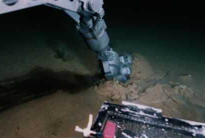
Mineral resources of the bottom
In the Pacific Ocean there are the most significant areas of distribution of ferromanganese nodules - more than 16 million km 2. In some areas, the content of nodules reaches 79 kg per 1 m 2 (average 7.3-7.8 kg / m 2). Experts predict a bright future for these ores, arguing that their mass production can be 5-10 times cheaper than obtaining similar ores on land.
The total reserves of ferromanganese nodules at the bottom of the Pacific Ocean are estimated at 17 thousand billion tons. Pilot development of nodules is carried out by the United States and Japan.
Phosphorite and barite are distinguished from other minerals in the form of nodules.
Commercial reserves of phosphorites have been found near the California coast, in the shelf parts of the Japanese island arc, off the coast of Peru and Chile, near New Zealand, in California. Phosphorites are mined from depths of 80-350 m. The reserves of this raw material are large in the open part of the Pacific Ocean within the limits of underwater uplifts. Barite nodules have been found in the Sea of Japan.
Placer deposits of metal-bearing minerals are currently of great importance: rutile (titanium ore), zircon (zirconium ore), monazite (thorium ore), etc.
Australia occupies the leading place in their production; placers along its eastern coast stretch for 1.5 thousand km. Coastal placers of cassiterite concentrate (tin ore) are located on the Pacific coast of mainland and insular Southeast Asia. Significant placers of cassiterite off the coast of Australia.
Titanomagnetite and magnetite placers are being developed near about. Honshu in Japan, in Indonesia, in the Philippines, in the USA (near Alaska), in Russia (near Iturup Island). Gold sands are known off the western coast of North America (Alaska, California) and South America (Chile). Platinum sands are mined off the coast of Alaska.
In the eastern part of the Pacific Ocean, near the Galapagos Islands in the Gulf of California and in other places in rift zones, ore-forming hydrotherms (“black smokers”) have been identified - outcrops of hot (up to 300-400 ° C) juvenile waters with a high content of various compounds. Here is the formation of deposits of polymetallic ores.
Among non-metallic raw materials located in the shelf zone, glauconite, pyrite, dolomite, building materials - gravel, sand, clay, limestone-shell rock, etc. are of interest. Offshore deposits, gas and coal are of greatest importance.
Oil and gas shows have been found in many areas of the shelf zone in both the western and eastern parts of the Pacific Ocean. The United States, Japan, Indonesia, Peru, Chile, Brunei, Papua, Australia, New Zealand, Russia (in the region of Sakhalin Island) are producing oil and gas. The development of oil and gas resources of the Chinese shelf is promising. The Bering, Okhotsk and Japanese seas are considered promising for Russia.
In some areas of the Pacific shelf, coal-bearing seams occur. The extraction of coal from the bowels of the seabed in Japan is 40% of the total. On a smaller scale, coal is mined by sea in Australia, New Zealand, Chile and some other countries.
The area of the Pacific Ocean with seas is 178.7 million km 2, which is about half of the water area of the World Ocean or more than 1/3 of the surface of the globe. The shape of the ocean is isometric, slightly elongated from northwest to southeast. Its length from north to south is about 16,000 km, from west to east up to 20,000 km. It contains about 710.4 million km 3 of water, which corresponds to 53% of the volume of water in the World Ocean. 78.9% of its area falls at depths from 3000 to 6000 m. The average depth of the ocean is 3976 m, the maximum is 11,022 m.
In the west, the ocean boundary runs along the coast of Asia, the Strait of Malacca, the western and southern outskirts of the Malay Archipelago, New Guinea, the Torres Strait, the coast of Australia, the Bass Strait, the island of Tasmania and further along the meridian of Cape South to the intersection with Antarctica, in the south - along the coast Antarctica, in the east - along the Drake Strait from Cape Sternek on the Antarctic Peninsula to Cape Horn in the Tierra del Fuego archipelago, along the coast of South and North America, in the north - along the Bering Strait.
The outlines of the coastline are very complex on the western periphery of the ocean and relatively simple on the eastern. In the west, the transition zone between the ocean floor and the continents is represented by a complex complex of marginal and interisland seas, island arcs, and deep-water trenches. The most significant horizontal and vertical dissection of the earth's crust is observed here. In the east, the coast of North and South America is slightly indented, there are no marginal seas and large clusters of islands, deep-sea trenches are located directly at the continents.
The peculiarities of the geographical position and the huge size of the Pacific Ocean help to reduce the cooling effect of the waters of the Arctic Ocean, but increase the influence of Antarctica, in connection with this, the northern part of the ocean is warmer than the southern. Most of the ocean is located in the equatorial tropical latitudes, so it is the warmest of all oceans. The position of the ocean in all latitudes determines the diversity of its natural conditions and resources, as well as the allocation within its boundaries of all physiographic zones, with the exception of the Arctic.
In the Pacific Ocean, there are many different islands in terms of genesis, area and configuration. In terms of their number and total area (about 3.6 million km), it ranks first among the oceans. Volcanic islands are found throughout the ocean (Aleutian, Kuril, Ryukyu, Hawaiian, Chatham, Easter, Galapagos, etc.) Continental-type islands are located mainly in the western part of the ocean (Sakhalin, Japanese, Taiwan, large islands of the Malay Archipelago, New Zealand and etc.). Biogenic islands are located mainly in the equatorial-tropical latitudes (Caroline, Marshall, Gilbert, Fiji, Tuamotu, etc.). The islands of the central and southwestern parts of the ocean are united under the common name Oceania.
Geological structure and bottom topography. Underwater margins of the continents occupy 18.2 million km 2 or about 10.2% of the area of the Pacific Ocean, including the shelf accounts for 5.4%, the continental slope 3.0% and the continental foot 1.8%. They are most widely represented in the marginal seas of the western coastal sector, the region of the Malay Archipelago, off the northern and eastern coasts of Australia.
In the Bering Sea, about half of the bottom area falls on the shelf with shallow depths and a leveled relief. It is characterized by the presence of traces of flooded river valleys and relict forms of glacial relief processed by later marine abrasion-accumulative processes. The continental slope is relatively wide with signs of fault-block dissection and large underwater canyons. The continental foot is weakly expressed, in the form of a monotonous and narrow accumulative plume.
On the shelf of the Sea of Okhotsk, a coastal shallow is clearly distinguished, which is an abrasion-accumulative plain bounded by an isobath of 100 m and a submerged shelf that occupies the entire central part of the sea with separate depressions up to 1000-1500 m. . The continental foot is a narrow plain formed by the products of the removal of turbidity flows and landslide masses. In the Sea of Japan, the shelf is poorly expressed and occupies a significant area only in the Tatar Strait. The continental slope is represented by a narrow strip of a steeply sloping bottom. The relief of the shelf of the East China and Yellow Seas is leveled due to the powerful alluvial deposits of the Yangtze and Yellow Rivers. Only in the coastal strip are sandy ridges formed by tidal currents. In the South China Sea and the seas of the Malay Archipelago, the underwater margin of the continents is also well developed. In the structure of the shelf zones, a significant role is played by coral structures and features of accumulation, carbonate and pyroclastic sediments.
To the north of Australia stretches a vast shelf, characterized by the widespread distribution of carbonate sediments and coral reefs. To the east of Australia is the world's largest lagoon, separated from the sea by the world's largest barrier reef. The Great Barrier Rift is a discontinuous strip of coral reefs and islands, shallow bays and straits, stretching in the meridional direction for almost 2500 km, about 2 km wide in the northern part, and up to 150 km in the southern part. In the east, the reef almost sheer wall breaks off to the mainland slope. A peculiar morphostructure of the Paleozoic age is the New Zealand Plateau, which is a block of the continental crust not connected with the mainland. From almost all sides, the plateau is bounded by wide, dissected underwater canyons, the continental slope gradually turning into the foot.
The relief of the underwater margin of North America is characterized by significant fragmentation, the presence of numerous depressions, flat-topped elevations, and wide transverse valleys. Off the coast of Alaska, it has traces of glacier processing. The maximum fragmentation, with a well-pronounced tectonic dismemberment, is the relief of the Californian borderland. The shelf is narrow and limited by a ledge at depths of 1000-1500 m. Off the coast of Central and South America, the shelf is very narrow, up to several kilometers wide. South of 40°S sh. it expands somewhat, but is highly fragmented. The role of the continental slope is played by the near-continental sides of the deep-sea trenches. The continental foot is practically not expressed.
The continental margin of Antarctica is distinguished by the deep position of the shelf edge (mainly up to a depth of 500 m), dissected relief, and a wide distribution of glacial and iceberg deposits. The continental slope is wide, cut by submarine canyons. The well-developed continental foot is represented by a gently undulating sloping plain.
Regions of the transition zone The Pacific Ocean occupies 13.5% of its area and represents a natural combination of marginal sea basins, island arcs and deep-sea trenches. They are at different stages of development and differ in the set, configuration and location of these components. They are characterized by a complex structure of the earth's crust belonging to the geosynclinal type. They are seismic and together form the Pacific ring of earthquakes and modern volcanism.
The following transitional regions are distinguished in the Western Pacific sector: Aleutian, Kuril-Kamchatka, Japanese, East China, Indonesian-Philippine, Bonin-Marian, Malesia, Vityazev, Tongo-Kermadek and Macquarie. In this part of the ocean, younger transitional areas are located on the border with the ocean floor, those at a later stage of development are located closer to the continents or are separated from the ocean floor by well-developed island arcs (Aleutian, Kuril-Kamchatka) and islands with a continental crust (Japanese) .
There are two transitional regions in the East Pacific sector: Central American and Peru-Chile. Here the transition zone is expressed only by deep-water trenches. There are no marginal seas and island arcs. The role of island arcs in this zone is played by young folded structures of Central and South America.
mid-ocean ridges occupy 11% of the area of the Pacific Ocean and are represented by the South Pacific and East Pacific Rise. In essence, this is a single structure, with a length of about 11,700 km, which is part of the planetary system of mid-ocean ridges. They are characterized by a vault-like structure, a considerable width (up to 2000 km), and a discontinuous strip of axial rift valleys crossed by transverse transform faults. The rift system of the axial zone is less pronounced than in the Mid-Atlantic and other ridges of this type. But such features of the structures under consideration as a high density of the earth's crust under the ridge, seismicity, volcanism, high values of the heat flow, and a number of others, are very clearly manifested. North of the equator, the East Pacific Rise narrows. The rift zone of the ridge becomes more pronounced. In the California area, this structure invades the mainland. This is associated with the formation of the California Borderland, the large active San Andreas fault, the depressions of Sacramento and the Yosemite Valley, blocky structures of the Great Basin and the main rift of the Rocky Mountains. The mid-ocean rises of the Pacific Ocean have lateral branches in the form of the Chilean rise and the Galapagos rift zone. In addition, the system of mid-ocean ridges includes the underwater ridges of Gorda, Juan de Fuca and Explorer located in the northeast of the ocean. The mid-ocean ridges are characterized by a rift-type crust, which is characterized by a higher density than the oceanic one.
Lodge of the Pacific occupies 65.5% of its area and is almost completely located within the oceanic lithospheric plate, the surface of which is located at an average depth of 5500 m. Mid-ocean rises divide the ocean floor into two parts that differ in size and features of the bottom relief. The eastern part is occupied by extensive basins and morphostructures associated mainly with the East Pacific Rise. The western sector is characterized by a more complex structure and a variety of landforms. Almost all morphological types of underwater uplifts of the ocean floor are found here: oceanic swells, blocky mountains, volcanic ridges, marginal swells and ridges, individual mountains (guyots). The ridges and uplifts of the Pacific Ocean are separated from each other by oceanic basins. The main ones are: North-West (6671 m), North-Eastern (7168 m), Philippine (7759 m), East Mariana (6440 m), Central (6478 m), West Caroline (5798 m), East -Caroline (6920 m), Melanesian (5340 m), Southern (6600 m), Chilean (5021 m) and Bellingshausen (5290 m). The relief of the bottom of the basins is characterized by hilly, sometimes flat (Bellingshausen basin) abyssal plains, individual underwater peaks, guyots and latitudinal faults up to 4000-5000 km long. The largest faults are confined to the Northeast Basin: Mendocino, Murray, Molokai, Clarion, Clipperton. Significant faults in the eastern part of the ocean are also found south of the equator: Galapagos, Marquesas, Easter, Challenger.
Basins and uplifts of the Pacific Ocean floor correspond to oceanic-type crust. The place of the granite layer is occupied by the “second layer”, consisting of compacted sedimentary or volcanic rocks. The thickness of the sedimentary layer varies from 1000 to 2000 m; in places it is absent. The thickness of the “second layer” varies from several hundred to several thousand meters; in some areas it is also absent. The average thickness of the basalt layer is about 7000 m.
Bottom sediments and minerals The Pacific Ocean is very diverse. Terrigenous sediments occupy about 10% of the area of the Pacific Ocean floor. They are mainly confined to the underwater margins of the continents, but they are also found in the marginal seas, deep-sea trenches, and even in separate parts of the ocean floor. Terrigenous iceberg deposits form a strip up to 1000 km wide off the coast of Antarctica. Of the biogenic sediments, carbonate foraminiferal sediments are the most common (about 38%), occupying significant areas of the bottom south of the equator to 60°S. sh. In the northern hemisphere, their development is limited to the summit surfaces of ridges and other uplifts, and benthic foraminifera predominate in the composition of silts. Pteropod deposits occupy several areas of the bottom in the Coral Sea. Coral sediments occupy less than 1% of the ocean area and are located on the shelves and continental slopes in the equatorial-tropical zone. Shell sediments are found on all shelves, except for the Antarctic. Biogenic siliceous sediments cover more than 10% of the bottom area and form three main belts: the northern and southern siliceous diatom oozes in high latitudes and the equatorial siliceous radiolarian. Pyroclastic deposits are observed in areas of modern and Quaternary volcanism. Due to the predominance of depths of more than 4500-5000 m, significant areas of the bottom in the Pacific Ocean (about 35%) are covered with deep-sea red clay.
Almost everywhere on the bed of the Pacific Ocean, iron-manganese nodules are distributed, occupying an area of about 16 million km 2. The average content of nodules is 7.3-7.8 kg / m 2, and in some areas of the ocean it reaches 70 kg / m 2. Their total reserves are estimated at 17 thousand billion tons. Pilot development of iron-manganese nodules is carried out by the USA and Japan. Phosphorite and barite are distinguished from other minerals in the form of nodules. Commercial reserves of phosphorites have been found off the Californian coast, on the shelf of the Japanese Islands, off the coast of Peru and Chile, New Zealand, on underwater rises in the open part of the ocean, and in other areas. Potential reserves of this raw material are estimated at hundreds of billions of tons.
Of great importance are the placer deposits of metal-bearing minerals discovered in the Pacific Ocean: rutile (titanium ore), zircon (zirconium ore), monocyte (thorium ore) and others. The leading place in their extraction is occupied by Australia, where placers stretch for 1.5 thousand km along the eastern coast. Coastal-marine placers of cassiterite (tin ore) are located on the Pacific coast of Southeast Asia and Australia. Titanium-magnetite and magnetite (iron ore) placers are mined in the area of the Japanese Islands, the Malay Archipelago, the Kuril Ridge and the coast of Alaska. Deposits of gold sands are found off the western coast of North (Alaska, California) and South (Chile) America. Platinum sands are mined off the coast of Alaska. In the eastern part of the Pacific Ocean near the Galapagos Islands, in the Gulf of California and other regions in the region of rift zones, ore-forming hydrotherms have been identified.
Of non-metallic minerals, deposits of glauconite, pyrite, dolomite, building materials: gravel, sand, clay, limestone-shell rock, etc. should be noted. Significant oil and gas deposits have been discovered in many areas of the Pacific shelf zone. In some areas of the shelf near the coasts of Japan, Australia, New Zealand and South America, coal seams occur.
Climate the Pacific Ocean is determined by the planetary patterns of distribution solar radiation and atmospheric circulation.
The annual amount of total solar radiation varies from 3000-3200 MJ/m 2 in subarctic and antarctic latitudes to 7500-8000 MJ/m 2 in equatorial-tropical latitudes. The value of the annual radiation balance ranges from 1500-2000 to 5000-5500 MJ/m 2 . In January, a negative radiation balance is observed to the north of the line: the middle part of the Sea of Japan - the southern tip of about. Vancouver (up to -80 MJ / m 2); in July - south of 50 ° S. sh. The balance reaches its maximum monthly value (up to 500 MJ/m2) in the tropics, in January in the southern hemisphere, and in July in the northern hemisphere.
In the temperate latitudes of the northern hemisphere, the Aleutian minimum is located, which is more pronounced in winter. In the subpolar region of the southern hemisphere, the Antarctic Low Pressure Belt stands out. In the subtropical latitudes of both hemispheres above the ocean, there are centers of two permanent baric maxima: the North Pacific (Hawaiian) and the South Pacific. Along the equator is the equatorial depression. The formation of the climate of the Pacific Ocean is also influenced by baric centers formed over adjacent continents: the seasonal Asian maximum (winter), the reversible Australian baric center (maximum in winter and minimum in summer of the southern hemisphere) and the constant Antarctic high pressure area.
In accordance with the distribution of the main baric centers, wind systems are formed. Subtropical highs and equatorial depression cause the formation of trade winds in tropical latitudes. The frequency of trade winds in the southern hemisphere is about 80%, at a speed of 6-15 m/s (sometimes up to 20 m/s), in the northern hemisphere up to 60-70%, at a speed of 6-10 m/s. Calm weather prevails in the trade wind convergence zone. In temperate latitudes, westerly winds are most characteristic, especially in the southern hemisphere, where they have the greatest strength and constancy. At high latitudes, easterly winds are observed off the coast of Antarctica. The monsoonal circulation is pronounced in the northwestern part of the Pacific Ocean. Winter north and northwest winds are replaced by south and southeast winds in summer. The maximum wind speeds are associated with the passage of tropical cyclones. The areas of their occurrence lie between 20° and 5° latitude in each hemisphere, with a maximum of recurrence in summer and autumn. The greatest number of tropical cyclones in the Pacific Ocean is observed in the area located between the Yellow Sea, the Philippine Islands and 170 ° E. e. On average, there are 27 typhoons per year, in some years up to 50, of which about half have a hurricane wind speed of more than 33 m/s.
Medium air temperature February in equatorial latitudes is + 26 - + 28 °С, off the coast of Antarctica it drops to -10 °С, and in the Bering Strait to -20 °С. The average temperature in August varies from 26 - + 28 °С near the equator to +5 °С in the Bering Strait and to -25 °С near Antarctica. Maximum air temperatures (up to +36 - +38 °С) are observed in the area of the northern tropic to the east of the Philippine Sea, as well as near the Californian and Mexican coasts. The minimum ones are observed in the Antarctic (up to -60 °С). The largest annual temperature amplitudes are characteristic of the northwestern monsoon region off the coast of Asia - 20-25 °C. In equatorial latitudes, the amplitude does not exceed 2-4 °C.
The distribution of air temperature over the ocean is significantly influenced by the continents, prevailing winds and ocean currents. Within the equatorial-tropical zone, the western part of the Pacific Ocean, with the exception of the area adjacent to Asia, is warmer than the eastern one. In the temperate latitudes of the northern hemisphere, on the contrary, the west is colder than the east. In the temperate zone of the southern hemisphere, such differences are not observed.
Average annual cloudiness over the Pacific Ocean reaches maximum values in temperate latitudes - 7-9 points. In the equatorial regions, it is somewhat lower and amounts to 6-7 points. In the zone of action of subtropical baric maxima, cloudiness decreases to 3-5 points, and in some areas of the southern hemisphere - to 1 point.
The largest number precipitation falls in the equatorial-tropical trade wind convergence zone, where intense ascending air currents develop. Here the annual amount of precipitation exceeds 3000 mm. In temperate latitudes, the amount of precipitation is from 1000 mm in the west to 2000 in the east of the ocean. The smallest amount of precipitation falls in the zone of action of the eastern periphery of subtropical baric maxima, where descending air currents dominate and cold ocean currents pass. To the west of the California Peninsula, the annual precipitation does not exceed 300 mm, and off the coast of Peru and northern Chile, 100 or even 30 mm. In the western parts of the subtropical regions, the amount of precipitation increases to 1000-2000 mm. In the high latitudes of both hemispheres, due to low air temperature and low evaporation, the amount of precipitation decreases to 300 mm in the north and 100 in the south. In the intertropical convergence zone and subtropical high pressure areas, precipitation occurs almost uniformly throughout the year. In the area of the Aleutian Low, as well as in the temperate and subpolar latitudes of the southern hemisphere, the frequency of precipitation increases in winter. In the monsoonal region of the northwestern Pacific Ocean, the maximum precipitation occurs in the summer.
mists most often formed in temperate latitudes, especially over the water area adjacent to the Kuril and Aleutian Islands, where the average annual number of days with fog reaches 40, with a maximum in summer. In temperate latitudes of the southern hemisphere, their number generally does not exceed 10-20 days.
hydrological regime. Location surface currents in the Pacific Ocean is mainly determined by the features of the atmospheric circulation over its waters and adjacent continents. In the ocean, circulation systems similar to atmospheric and genetically determined by them are formed. North of 40°N a subpolar cyclonic circulation is distinguished, consisting of the Alaska, Aleutian, Kamchatka, Kuril and North Pacific currents. To the south of this system of currents, there is a subtropical anticyclonic gyre formed by the Sulfur trade wind, Kuroshio, North Pacific and California currents. At low latitudes, the Northern trade wind, Intertrade (Equatorial countercurrent) and Southern trade wind currents form two narrow tropical cyclonic gyres. In the Southern Hemisphere, there is also a subtropical anticyclonic circulation, consisting of the South trade winds, East Australian, West winds and the Peruvian currents. The current of the Western winds interacts with the weakly expressed coastal Antarctic current of the east direction, forming the southern subpolar cyclonic circulation. Alternating anticyclonic and cyclonic circulations of currents are not completely closed systems. They interact with each other and are connected through common currents.
An important role in the circulation of the waters of the Pacific Ocean belongs to the subsurface compensatory Cromwell current, moving under the South trade wind current at a depth of 50-100 m in an easterly direction. The length of this current is about 7000 km, the width is about 300 km and the speed is from 1.8 to 3.3 km/h. The average speed of most of the main surface currents is 1-2 km/h, Kuroshio and Peruvian up to 3 km/h.
In the Pacific Ocean, the highest wind waves(up to 34 m). Increased wave activity is observed between 40-50°N. sh. and 40-60°S sh., where during a storm the wavelength reaches 100-120 m, the height is 6-8 m, sometimes up to 15-20 m, with a period of 10 s. The area with maximum storm activity is located between Antarctica and New Zealand in the vicinity of Macquarie Island, with an average wave height of about 3 m. Tsunamis are often observed in the area of the islands and the coast of the Asian continent in the northern and northwestern parts of the ocean, as well as off the coast of South America. .
Irregular semidiurnal periods are observed over most of the Pacific Ocean. tides. Regular semidiurnal tides prevail in the southern part of the ocean. Small areas in the equatorial region and in the north (Kuril Islands, east of Kamchatka) have diurnal tides. The average value of tidal waves is 1-2 m. In the bays of the Gulf of Alaska - 5-7 m, in the Gulf of Cook - up to 12 m. The maximum tide value was noted in the Penzhina Bay (Sea of Okhotsk) - 13.2 m.
The Pacific Ocean is the warmest of the oceans. Average annual temperature his surface water is 19.1°C. This is due to the huge size of the ocean, the location of most of it (about 50%) in equatorial tropical latitudes and significant isolation from the Arctic Ocean.
The temperature distribution of the surface waters of the Pacific Ocean is determined mainly by heat exchange with the atmosphere and water circulation, which often violates the sublatitudinal variation of isotherms. The highest annual and seasonal water temperatures are observed in the equatorial-tropical latitudes - +25 - +29 °С. In the equatorial-tropical and subtropical zones, the western part of the ocean is warmer than the eastern part by 2-5 °C. In temperate and subpolar latitudes of the northern hemisphere throughout the year, the western sector of the ocean is colder than the eastern one by 3-7 °C. In summer, the water temperature in the Bering Strait is +5 - +6 °С. In winter, the border of negative temperatures passes in the middle part of the Bering Sea. In the temperate and polar latitudes of the southern hemisphere, there are no significant differences in water temperature between the western and eastern parts of the ocean. In the area of floating ice in Antarctica, the water temperature rarely rises to +2 - +3 °С even in summer. In winter, negative water temperatures are observed south of 60-62 ° S. sh.
Salinity distribution The waters of the Pacific Ocean are determined mainly by the processes of moisture exchange on the surface and the circulation of waters. The water balance of the ocean is characterized by a significant excess of the amount of atmospheric precipitation and river runoff over the amount of evaporation. The salinity of its waters at all depths is lower than in other oceans. The highest salinity values of surface waters are observed in the subtropics up to 35.5 ‰ in the Northern Hemisphere and up to 36.5 ‰ in the Southern Hemisphere.In the equatorial zone, salinity decreases to 34.5 ‰ and less, in high latitudes - up to 33 ‰ in the south. Along the shores in the east of the ocean, currents carry less saline waters from high latitudes to lower latitudes, in the west - more saline waters from low latitudes to high latitudes.
ice formation in the Pacific Ocean occurs in the Antarctic regions, as well as in the Bering, Okhotsk, Japanese and Yellow Seas, the Gulf of Alaska, the bays of the eastern coast of Kamchatka and the island of Hokkaido. There is no permanent ice in the northern part of the ocean. The limiting age of the ice is 4-6 months, the thickness is 1-1.5 m. Floating ice does not fall below 40 ° N. sh. at about. Hokkaido and 50° N. sh. off the eastern shores of the Gulf of Alaska. The removal of ice from the Arctic Ocean is practically absent. In the north of the Gulf of Alaska there are several coastal glaciers (Malaspina) that form small icebergs. Usually, ice in the northern part of the ocean is not a serious obstacle to ocean navigation. In the southern part of the ocean, large masses of ice are constantly present, and all its types extend far to the north. The average boundary of floating Antarctic ice in winter passes in the region of 61-64 ° S. sh. In some years with severe winters, ice extends up to 56-60°S. sh. In summer, the edge of floating ice is located at about 70 ° S. sh. Multi-year pack ice, typical for the Central Arctic, is absent in the Antarctic. Powerful continental glaciers of Antarctica give rise to numerous icebergs, which are carried out to 48-48 °S. sh. The main iceberg formation areas are the Ross and Amundsen Seas. The average size of icebergs is 2-3 x 1-1.5 km, the maximum is up to 400 x 100 km. The height of the above-water part varies from 10-15 m to 60-100 m.
Transparency water in the temperate and Antarctic latitudes of the Pacific Ocean ranges from 15 to 25 meters. In the equatorial-tropical latitudes, transparency increases to 30-40 m in the east and up to 40-50 m in the west of the ocean.
The Pacific Ocean has the following types of water masses: surface, subsurface, intermediate, deep and bottom. The properties of surface water masses are determined by the processes of heat and moisture exchange on the surface of the ocean. They have a thickness of 30-100 m, are distinguished by the relative uniformity of temperatures, salinity, density and seasonal variability of properties. Under the conditions of the temperate zone, subsurface waters are formed as a result of autumn-winter cooling and wind mixing of water, and in warm climates - by sinking more saline surface waters. They differ from surface ones in increased salinity and density, at a water temperature in the tropics and subtropics of 13-18 ° C, and in temperate latitudes 6-13 ° C. Depending on climatic conditions, the depth of their boundary with intermediate waters ranges from 200 to 600 m. Intermediate water masses in the northwestern part of the ocean are formed as a result of submersion of cold waters from the Bering Sea, in the Antarctic regions - due to the sinking of waters cooled on the Antarctic shelf, in other areas - through local climatic conditions and features of the vertical circulation of water. In temperate and high latitudes, they have a temperature of 3-5 ° C and a salinity of 33.8-34.7 ‰. The lower boundary of this structural zone is located at a depth of 900 to 1700 m. The deep water masses of the Pacific Ocean are formed mainly as a result of the sinking of the cold waters of the Antarctic and the Bering Sea, followed by their spreading over the basins. Their lower boundary runs at a depth of 2500-3000 m. Bottom water masses form on the Antarctic shelf and gradually spread along the bottom, filling all the basins of the ocean. They are characterized by uniform salinity (34.6-34.7‰) and low temperature (1-2°C). Deep and bottom water masses make up about 75% of the volume of the waters of the Pacific Ocean.
Due to the vast size of the water area and the variety of natural conditions organic world The Pacific Ocean is the richest in terms of the number of species, ecological communities, total biomass and commercial biological resources. The phytoplankton of the Pacific Ocean is represented mainly by unicellular algae (about 1300 species), almost all of which belong to the peridineans and diatoms. Most of the vegetation is concentrated in the coastal zone, relatively shallow ocean areas and upwelling areas. The high and temperate latitudes of both hemispheres are characterized by the mass development of brown algae, especially the kelp group. Fucus, large green (up to 200 m long) and calcareous red algae are widespread in equatorial-tropical areas. Donna vegetation of the Pacific Ocean has about 4 thousand species of algae and up to 30 species of flowering (sea grasses).
The fauna of the Pacific Ocean is 3-4 times richer in species composition than in other oceans. All groups of animal organisms living in the oceans are represented here. The fauna of the western regions of the Pacific Ocean in the equatorial-tropical regions is especially rich in the number of species. In the seas of the Malay Archipelago, there are more than 2 thousand species of fish, while only about 300 are known in the seas in the north of the ocean. But even in these waters, the number of fish species is twice as large as in similar seas of other oceans. Coral fauna is widely developed in the area of the Sunda Islands and northeast of Australia. Over 6,000 species of molluscs live in tropical waters. The fauna of the deep-sea parts of the ocean is peculiar. At depths of more than 8.5 km, 45 species of animals live, of which approximately 70% are endemic. Holothurians, laminabranchs, polychaetes, brittle stars, and other organisms adapted to life in the ultraabyssal zone predominate here. The fauna of the Pacific Ocean is distinguished by the antiquity of many systematic groups, the endemism and gigantism of their representatives. Ancient sea urchins and fish (Jordan, Gilbertidia, etc.) live here, endemic mammals - fur seal, sea beaver, sea lion, giant mussels, oysters, the largest bivalve mollusk tridacna, weighing up to 300 kg.
The Pacific Ocean is characterized by high biological productivity. The distribution of primary production and biomass is determined by latitudinal geographic zoning, the position of the main oceanic water cycles and dynamic zones (convergence, divergence, upwelling). Areas of significant productivity are confined to subpolar, temperate and equatorial zones (250-500 mg C/m 2). Within these zones, the maximum values of primary production and biomass correspond to the upwelling zones. In tropical latitudes, bioproductivity is significantly lower (100 mg C/m2 or less). In the central regions of subtropical gyres, it is minimal and does not exceed 50 mg C/m 2 .
In the Pacific Ocean, three biogeographic regions are distinguished: the North Pacific, Tropical-Indo-Pacific and Antarctic. The North Pacific region is characterized by salmon and Far Eastern sardines; Tropical-Indo-Pacific - sharks, flying fish, tuna, etc.; Antarctic - noto-shadow.
The first place among the commercial biological resources of the Pacific Ocean is occupied by fish (85% of the catch), the second - by mollusks, crustaceans, echinoderms and other non-fish species, including algae (10%), the third - by marine mammals (5%). The Pacific Ocean accounts for 45% of the world's fish.
The main fishing areas are located in the northwestern, northeastern, eastern and southeastern parts of the ocean. These are the areas of interaction between warm waters of the Kuroshio and cold streams of the Kuril Current, the zone of penetration of the warm Alaska Current into high latitudes, shelf areas in the west of the ocean, and upwelling zones off the coasts of North and especially South America. Since the 1970s, the catch of fish in the Antarctic regions has been noticeably increasing. The main commercial fish of the Pacific Ocean: pollock, anchovy, herring, sardine, horse mackerel, mackerel, saury, salmon, tuna, cod, hake. flounder, halibut, sea bass. Also in the ocean is fishing for whales and a variety of invertebrates. Mariculture has received significant development, especially in recent years.
In the Pacific Ocean, all physical-geographical zones except for the Arctic. Due to significant differences in the natural conditions of the western, eastern and central regions of the ocean, within the belts they distinguish physical-geographical regions. When determining regions, the features of their geographical location, climatic conditions, hydrological regime, the degree of severity of natural processes and phenomena, etc. are taken into account. In the western part of the Pacific Ocean, marginal seas are usually distinguished as physiographic regions, and in the eastern part, zones of intense upwelling. Northern subpolar belt: Bering Sea, Sea of Okhotsk; northern temperate zone: Alaska Bay area, Sea of Japan, Yellow Sea; northern subtropical belt: California region, Kuroshio, East China Sea; northern tropical belt: Philippine region, South China Sea, Gulf of California; equatorial belt: Panama region, Australo-Asian seas, New Guinea sea, Solomon sea; southern tropics: Peruvian region, Eastern region, Coral Sea with the Great Barrier Reef sub-region; southern subtropical belt: Tasman Sea; southern temperate zone: Chilean region; southern subpolar belt; south polar belt: Ross Sea.
The Pacific Ocean stretches over a huge area and is the deepest. It washes almost all the continents of the globe with the exception of Africa.
In addition, it has great historical and economic significance.
This topic is studied at school in geography lessons in the 7th grade or earlier and is necessarily found in exam tests. Therefore, let us once again recall all the main things that characterize the Pacific Ocean.
Research History
It is believed that the conqueror Nunez de Balboa, who first saw the coast, discovered the Pacific Ocean. The first travels on the waters were carried out on rafts and canoes. The researchers on the Kon-Tiki raft even managed to cross uncharted waters.

It is interesting to know why the Pacific Ocean was called the Pacific. During the voyage of Ferdinand Magellan through its waters, not a single storm occurred in a little less than 4 months, the water surface was absolutely calm all the time of the trip.

In honor of this, the name appeared, translated into English as the Pacific Ocean.
Characteristics of the largest ocean
The area of the Pacific Ocean is 178.68 million km², it includes 28 seas, including the Yellow, Bering, and Okhotsk.

Surprisingly, it occupies almost half the area of the entire World Ocean (49.5%), exceeds half the volume of all water on Earth by 3%, which is why it is deservedly considered the largest.

The Mariana Trench is located in the Pacific Ocean, in which the maximum depth among the known ones is 11022 m. The average depth is 3984 m.
The salinity of water in the middle lane varies from 34 to 36%, while in the north it can reach 1%.
Geographical position
The Pacific Ocean occupies 1/3 of the globe. From the east it washes South and North America (their western coasts), from the west it touches the eastern coasts of Eurasia, Australia and Antarctica.

The border with the Arctic Ocean is determined only by the Bering Strait, which lies between the coasts of Eurasia and North America.
currents
There are 7 cold currents in the Pacific Ocean, the main ones are: the South trade wind current, the North Pacific current, the Cromwell current, the Alaska and the Inter trade wind countercurrent. There are only 3 warm ones: Californian, Peruvian and westerly winds.

Currents of the Pacific Ocean
In the region of Eurasia, monsoons blow on the coastal regions, especially in summer. At the equator, the trade winds have an active influence on the sea current.
In the west of the equator, a large amount of precipitation falls, on average 1500-2500 mm. In the east, precipitation is extremely rare, insignificant.
Seas
The area of the seas included in the composition is almost 20% of the total.

Bering Sea
It includes 27 seas, most of which are located along the coasts of Eurasia.

coral sea
The greatest historical and economic importance are: Bering, Coral, Japanese, Okhotsk, Tasmanovo and Philippine.
Climate and climatic zones
Due to its large area, the Pacific Ocean is located in all climatic zones. At the equator, the temperature can reach 24 0 C, while off the coast of Antarctica it drops to 0 and deforms into ice.

In the southern hemisphere, the strong influence is exerted by the trade winds - winds that, in given climatic conditions, cause a huge number of typhoons and tsunamis.
Inhabitants of the Pacific
There are about 4,000 species of fish in the Pacific Ocean.
The list below briefly lists the most famous and abundant species found there:

It is believed that the largest ocean has the richest aquatic flora and fauna. This was influenced not only by its length through all climatic zones, but by the diverse bottom relief and favorable temperature.
Islands and peninsulas
Most of the islands were formed as a result of volcanic eruptions and tectonic plate shifts.

Islands of New Guinea
In total, there are more than ten thousand islands on the territory of ocean waters, among which the second largest island is about. New Guinea - 829,000 km², in third place is about. Kalimantan - 736,000 km², the largest group of islands, the Greater Sunda Islands, is also located here.

Solomon islands
Of the most famous islands there are: Kuril, Philippine, Solomon, Galapagos.

Peninsula California
Among the singles, Sakhalin, Taiwan, Sumatra can be distinguished. California, Alaska, Kamchatka and Indochina are peninsulas that wash the waters of the Pacific Ocean.
gulfs
The ocean has only 3 large bays, 2 are located in the north (Shelikhov, Alaska).

Shelikhov Bay - a bay of the Sea of Okhotsk between the coast of Asia and the base of the Kamchatka Peninsula
The Shelikhov Gulf is part of the Sea of Okhotsk, and there are several large ports in the Gulf of Alaska.

gulf of california
The Gulf of California washes the shores of the California Peninsula, it contains 2 large islands.
Features of nature
The main natural features and characteristics of the ocean are its area and depth.

The Pacific Ring of Fire is one of the most active seismic zones in the earth's crust. It got its name from the fact that a long chain of volcanoes stretched along the entire coast of the Pacific Ocean.
In its waters there is an extremely rare natural phenomenon - the Fireball. Huge reserves of heat are hidden in the depths, thanks to which the richest flora and fauna appeared.
Bottom relief
At the bottom of the ocean there are many volcanoes of various sizes, some of which are still active. Also there you can find underwater basins (sometimes quite large), which are also called pools, as they resemble them in structure.

The relief of the bottom of the Pacific Ocean
Another characteristic feature of the bottom relief is depressions, sometimes reaching several tens of meters in depth. At much greater depths, flat seamounts are found in abundance.
The bottom relief is also different in that it is subject to constant changes due to the shift of tectonic plates and the eruption of underwater volcanoes.
Coastline
The coastline is slightly indented, it includes only 3 large bays and several peninsulas.

For the most part, from the side of North and South America, the coastline is flat, but it is inconvenient for navigation. Mountain ranges occupy a significant part of the coast, while natural bays and harbors are extremely rare.
Minerals
In the bowels of the ocean, according to scientists, there is about 1/3 of the world's oil reserves, in fact, therefore, there is an active extraction of it, as well as gas.

The shelves are rich in various minerals, ore, copper and nickel sources (the reserves are approximately equal to several billion tons). Recently, an abundant source of natural gases has been discovered, from which production is already underway.
The most curious of them:

Environmental Issues in the Pacific
For many years man has spent the richest resources of the Pacific Ocean, which has led to their significant depletion.

And numerous trade routes and mining have affected the environment and caused severe water pollution, which also had a detrimental effect on flora and fauna.
Economic importance
More than half of the world's catch comes from the Pacific Ocean. Surprisingly, most transport routes also run through the territory of its waters.

Transport routes carry out not only the transportation of passengers, but also the transportation of minerals, resources (industrial, food).
Conclusion
The Pacific Ocean is a huge source of natural resources. It plays an important role in the global economy and the Earth's ecology. However, excessive use of its resources can lead to the depletion of natural resources and pollution of the largest water basin on Earth.
We also recommend
 Smartphone xperia z5 premium black
 Download toilet paper business plan
 Description Nokia X2 dual sim on the Android platform, powerful processor and support for two sim cards
 Is it possible to open a hostel in an apartment?
 Services to the public: the most promising business ideas
 How to start farming?